The Principles and Methods of Topographical Surveys
 Topographical surveying is defined as the determination and recording of heights and coordinates data for a given surveyed location. The data from such recordings can then be used to produce various topographic products such as spot height and contour maps, and other terrain models of the area surveyed. This helps in describing the shapes and detailed characteristics of various ground features.
The General Principles Of A Topographical Survey:
There are a number of principles that govern the entire topographical surveys that are not unique to Vinci Surveys Limited. They include:
- Boundaries: Whereas boundaries form the bulk of cadastral survey, they are of equal importance in the topographical surveys. Recording your survey boundary helps in ensuring that the data obtained can be spatially located thereby making it easy to manage the collected points. In a topographical survey exercise, these boundaries are generally defined by the field boundary of the surveyed area and must be recorded immediately after instrument orientation.
- Features: Another important thing to be considered are the features located on the intended survey area. Such features may include archeological sites, buildings and even historical remains that are not to be included in the final topographical reports. As a general principle, it is recommended that the coordinates and levels associated with such features to be reordered but kept separately and assigned unique identifications.
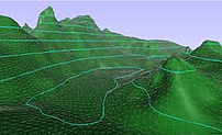
- Topographical Points: The main aim of the topographical surveys is to record ‘topo’ points that give the elevation data for the area surveyed. This is achieved by either recording points at high density over a given swath, or through even coverage and feature oriented point collection in cases where high density is not achievable. The main difference between even coverage and feature-oriented topographic surveys is that the latter involves equal point spacing while the former involves high-density point collection on a targeted feature.
- Break-lines: This is a specific point-sequence survey pattern that is employed in surveying features with clear boundaries. The main reason for this technique is that it allows for easy surface reconstruction of the intended feature in the offices.
- Reference Datum: Whenever viable and achievable, it is recommended for these ‘topo’ points to be referenced to a given set up OS datum, as opposed to some subjective grid or vertical reference framework.
Positioning Methods and Accuracies In Topographical Surveying
Techniques utilising single navigation frameworks are material for cases for which errors of ± 20m range are satisfactory. Specific cautionary measures, including experimental data calculation for adjustments based on known points (TBM) and restricting survey period to 2hours to dawn and sunset, are some of the most recommended practices of ensuring accuracy and good performance of a survey instrument.
There are several methods of topographical survey. However, triangulation and traverse methods are the most common and recommended. Triangulation involves angular measurements while traverse method, on the other hand, involves the measurement of both horizontal and angular measurements.
Topographical Survey Equipment
The topographical surveys equipment has evolved over time from the medieval Egyptian rope and plumb bob to the Total Station of the modern era. Even though this equipment is made up of several kinds, the most common ones are the Total Station, Dumpy Level, and Theodolite. Of course, these include the other innovative means of obtaining levels and distances on the earth surface through remote sensing and GPS.
1 Response
[…] techniques and modern satellite technology. Reference points are typically aligned to an Ordnance Survey datum to ensure standardized and reliable […]